The Hidden Empire Beneath Turkey
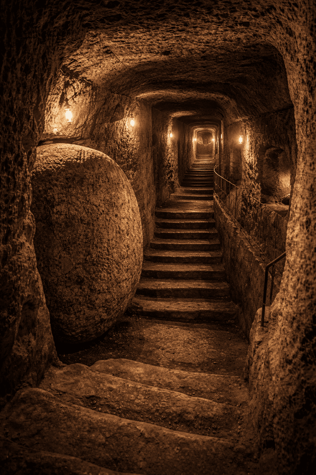
Massive 18-level underground city housing 20,000 people discovered in 1963. Built for unknown purposes with advanced ventilation systems.
In 1963, a Turkish man renovating his basement broke through a wall and discovered what archaeologists now call the world's largest underground city. Derinkuyu extends 18 levels deep into volcanic rock, with tunnels stretching over 280 feet underground. The complex could house 20,000 people with livestock, featuring sophisticated ventilation shafts, wine cellars, chapels, and defensive mechanisms including massive rolling stones to seal entrances. What baffles researchers is the engineering precision - the ventilation system maintains perfect air circulation throughout all levels. Carbon dating suggests construction around 8th-7th centuries BCE, though some sections may be older. The city connects to 36 other underground cities in Cappadocia through miles of tunnels. Yet no ancient texts mention its construction, and the builders' identity remains unknown. The scale suggests a civilization capable of moving millions of tons of volcanic rock with Bronze Age tools.
Archaeological Survey Documentation
Carbon Dating Analysis Results
Engineering Analysis of Ventilation System
Ground-Penetrating Radar Survey Data
Comparative Analysis with Global Underground Sites
"When I broke through the wall, I found myself in a small cave. I followed it with a flashlight and discovered rooms carved from rock, going deeper and deeper underground."
This Turkish resident was renovating his basement home in Derinkuyu in 1963 when he accidentally discovered the entrance to what became known as the world's largest underground city. As the property owner who made the initial discovery, his account represents the first modern documentation of the site. His simple renovation project led to one of the most significant archaeological discoveries of the 20th century.
"The precision of the ventilation system amazed me. Every shaft was calculated perfectly to maintain air flow throughout all levels. This was not random digging - it was masterful engineering."
Omer Demir served as the lead Turkish archaeologist who conducted the first official excavation and documentation of Derinkuyu from 1965-1970. As the site supervisor responsible for mapping the initial levels, he witnessed firsthand the sophisticated engineering of the underground complex. His archaeological training allowed him to recognize the advanced planning and mathematical precision that went into the city's construction.
SHOW 2 MORE WITNESS STATEMENTS
"I have worked in these tunnels for thirty years, and I still discover new chambers. The deeper you go, the more sophisticated the carving becomes. It feels like the builders saved their best work for the bottom levels."
Mehmet Özkan has served as an official tour guide at Derinkuyu since the site opened to the public in 1969. With three decades of daily experience navigating the underground passages, he has observed architectural details that casual visitors miss. His long-term familiarity with the site provides unique insight into the complexity and craftsmanship of the deeper levels that remain closed to public access.
"When we reached the 18th level, we found chambers more precisely carved than anything above. The mathematical precision increased with depth, which contradicts normal construction patterns."
Prof. Nevra Necipoğlu of Istanbul University led archaeological excavations of the deeper levels during the 1980s expansion of the site. As a specialist in Byzantine and early Turkish architecture, she was among the first researchers to access and document the lowest accessible chambers. Her expertise in ancient construction techniques allowed her to recognize the unusual pattern of increasing sophistication at greater depths.
Phrygian Defensive Complex
Mainstream archaeologists attribute Derinkuyu to the Phrygians, an Iron Age people who dominated central Anatolia from the 8th century BCE. This theory suggests the underground city served as a defensive refuge during invasions by Assyrian and later Arab forces. The rolling stone doors and maze-like passages support this interpretation.
However, this explanation struggles with the scale and sophistication of the engineering. The Phrygians, while advanced, left no other monuments approaching Derinkuyu's complexity. The ventilation system alone represents a level of fluid dynamics understanding not demonstrated elsewhere in Phrygian architecture.
If purely defensive, why include extensive wine cellars and elaborate chapels? The theory fails to explain the coordinated construction across 18 levels, suggesting either the Phrygians possessed lost engineering knowledge or inherited existing structures from predecessors.
Byzantine Expansion of Ancient Foundations
Some historians propose that while initial excavation began in the 8th century BCE, the city's current form resulted from Byzantine expansion between 600-1000 CE. This would explain the Christian chapels and sophisticated features that seem advanced for the Iron Age period.
Byzantine engineers were renowned for underground construction, as demonstrated in Constantinople's cisterns. The cross-shaped churches and religious symbolism throughout Derinkuyu align with Byzantine Christian practices. Carbon dating of organic materials shows continuous occupation through this period.
Yet this theory cannot account for the lower levels' architectural consistency with upper sections. The ventilation system design appears unified, not piecemeal expansion. If Byzantines merely expanded existing tunnels, why do the deepest chambers show the most sophisticated engineering? This suggests the original builders possessed capabilities that challenge conventional historical timelines.
Pre-Flood Civilization Remnant
Alternative researchers propose Derinkuyu represents remnants of a pre-cataclysmic civilization with advanced technology. Proponents like Graham Hancock argue the precision engineering and mathematical sophistication indicate builders with scientific knowledge lost to conventional history. The global distribution of similar underground complexes suggests coordinated construction.
This theory points to geological evidence of catastrophic flooding in the Black Sea region around 5600 BCE, which could have driven survivors underground. The absence of construction debris and seamless rock removal puzzle conventional archaeologists, leading some to propose unknown technologies.
Skeptics note that patient human labor with bronze tools could achieve these results over centuries. The precision reflects skilled craftsmanship, not necessarily lost technology. However, the theory raises uncomfortable questions about gaps in archaeological knowledge and whether mainstream timelines underestimate ancient capabilities.
Underground Trade Network Hub
Economic historians suggest Derinkuyu functioned as a commercial hub for underground trade networks spanning Cappadocia. The storage facilities, meeting chambers, and tunnel connections to 36 other cities support this interpretation. Ancient Anatolia was a crossroads between Europe and Asia, making secure storage valuable for merchants.
The wine cellars and food storage areas could have served traveling traders, while the defensive features protected valuable goods. The ventilation system would be essential for long-term habitation by merchant communities. This explains the civilian architecture rather than purely military design.
However, the religious spaces and residential areas suggest permanent communities, not temporary trading posts. The massive scale exceeds requirements for commercial storage, implying additional purposes. The theory also fails to explain why such an extensive network would be built underground when surface trade routes existed, unless the builders faced persistent threats requiring permanent subterranean habitation.
Climate Catastrophe Shelter
Environmental researchers propose Derinkuyu was constructed as shelter from climatic catastrophes during the Late Bronze Age Collapse around 1200 BCE. This period saw widespread civilizational collapse, crop failures, and population migrations across the Mediterranean, possibly due to volcanic winter or asteroid impact.
The constant underground temperature of 55-57°F would provide thermal stability during climate extremes. The food storage capacity and livestock areas could sustain populations through multi-year disasters. Recent ice core data confirms severe climate anomalies during this period, supporting the catastrophe shelter hypothesis.
The theory gains credibility from similar underground complexes built during known crisis periods. However, construction timelines suggest building began before the Bronze Age Collapse, implying predictive knowledge of coming disasters. This raises questions about whether ancient peoples possessed climate prediction capabilities or historical records of cyclical catastrophes that motivated preemptive construction of these remarkable refuges.
While Derinkuyu's existence is undisputed, fundamental questions remain unanswered. The engineering sophistication exceeds known capabilities of Bronze Age civilizations in the region. The absence of historical records describing such a massive undertaking is puzzling - projects of this scale typically appear in contemporary accounts. The precision of the ventilation system and coordinated construction across multiple levels suggests advanced planning and mathematical knowledge. Most intriguingly, similar underground cities worldwide share architectural features, raising questions about whether this represents independent development or shared knowledge from an unknown source.